From the hydrangea to the banana belt, Vila Franca do Campo
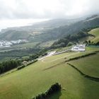
What the photo shows:
- The highest plantation of the Vila Franca banana belt
- The church of Nossa Senhora da Paz, which thrones 100 meters above it
The rest is explained here:
:
From the hortensia to the banana belt, Vila Franca do Campo
DrBestClimate
The text includes this line:
"The Vila Franca banana belt still accounts for 90% of the Azores banana production, although its arable land shrinked more in the last 35 years (construction, roads) than in the previous 350 years."
Related note about the apparently similar white units on each side of the road to nowhere:
. those on the foreground do not account for this destruction process (pineapple greenhouses).
- that's not the case for those on the background: it wasn't until this millenium that the "industrial zone" started to visually pollute one of the world's most unique landscapes.
Why so unique? Answer starts here:
World's highest climate gradients

World's highest climate gradients
DrBestClimate


Commentaire 0
Supprimer le commentaire
Effacer commentaire et réponses