Twilight of the Gods
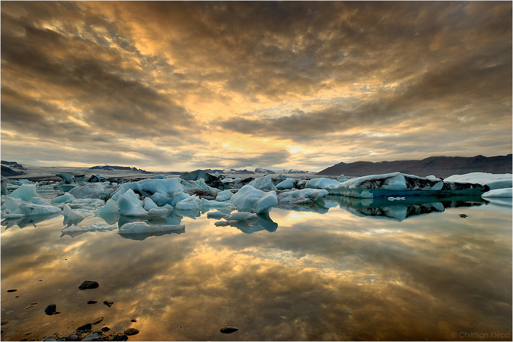
Etwa 11% Islands entsprechend einer Fläche von 11.000 km2 sind vergletschert mit 256 Kar- und Alpingletschern sowie 14 Eiskappen von denen 5 ausgedehnte Eisdome sind. Vatnajökull, der Wassergletscher, im Südosten ist größte Eiskappe mit einer Fläche von 8000 km2 und einer Höhe von bis zu 1725 m. Die Eiskappe ist bis zu 900 m tief mit einer mittleren Eismächtigkeit von 400 m. Die Eisscheide liegt im Zentrum am höchsten Punkt und das Eis fließt talwärts radial nach außen, dem unterliegenden Gelände und der Schwerkraft folgend. Scharfgratige Gipfel ragen als sogenannte Nunataks aus dem Eis. Die 20 Auslassgletscher des Vatnajökull erscheinen je nach unterliegendem Gelände als steile Eisfälle oder als gering geneigte Eisloben. Zwischen 500 und 1000 Jahre dauert die Reise des Eises bis zum jeweiligen Gletscherende. Bei 3 bis 15 m Schneefall pro Jahr und der Neigung des Geländes beträgt die Fließgeschwindigkeit des Eises etwa 1 m pro Tag, entsprechend 400 m pro Jahr. Die Eislobe des Breiðamerkurjökull endet im 200 m tiefen Gletschersee des Jökulsárlón, der wegen seiner Verbindung zum Ozean mit Brackwasser gefüllt ist. Die Eisberge im Jökulsárlón sind somit etwa 1000 Jahre alt und enthalten schwarze Ascheschichten zahlreicher Vulkanausbrüche.
Juli 2010
Canon 5D MkII, Canon L 16-35 mm, f/16, 0.8 Sek, ISO 50, Stativ
Mehr Information:
www.lichtjahre.eu
Where Geoscience Meets Art
--------
About 11% of Iceland is covered by glaciers corresponding to an area of 11.000 km2 (4247 mi2). This comprises a total of 256 cirque and alpine type glaciers and 14 ice caps of which 5 are extended ice domes. Vatnajökull, meaning water glacier, in the Southeast of Iceland is the largest of these covering an area of 8000 km2 (3089 mi2) at a height up to 1725 m (5659 ft). The glacier ice is up to 900 m (2950 ft) thick with 400 m thickness (1300 ft) on average. The ice divide is located on top of the ice cap with the ice flowing downward and outward following gravity and terrain. Several jagged peaks protrude from the ice as nunataks. Depending on the topography of the underlying terrain the 20 outlet glaciers of Vatnajökull appear either as steep ice falls and or gently sloped ice lobes. It takes 500 to 1000 years for the ice to reach the glacier snout. 3 to 15 m (10 to 50 ft) snowfall per year and the sloped terrain result in an ice drift of the outlet glaciers of about 1 m (3.3 ft) per day or 400 m (1300 ft) per year. This lobe of Breiðamerkurjökull ends in the 200 m (656 ft) deep proglacial and semi-saline tidewater lake Jökulsárlón. Hence the icebergs in Jökulsárlón are approximately 1000 years old and contain black ash layers from various volcanic eruptions.
July 2010
Canon 5D MkII, Canon L 16-35 mm, f/16, 0.8 sec, ISO 50, tripod
More Information:
www.lichtjahre.eu
Where Geoscience Meets Art


Cranach 14/08/2011 10:37
in herrliches Lanschaftsbild mit tollen Farben !!!!!!!!!!!!!!Roger Riechel 12/07/2011 17:49
feine spiegelunglg roger
MelinaMädchen 05/07/2011 14:01
Viele Daumen hoch für dieses wunderbare Foto!Lieber Gruß
fotoallrounderin 19/05/2011 12:07
natur die begeistert - auch auf deinem bild....pic: die ausgeglichenheit zwieschen himmel und dessen spiegelung sind einmalig - dir super gelungen. die bildquali: allerfeinste sahne !
merci für den ausführlichen, sehr interessanten text.
lg rosalie
Stefan Thaler - thalerst 28/04/2011 20:25
Dieses Licht ist einmalig!!Olaf Jäckel 22/01/2011 5:57
wundervoll!!!!man könnte auch hier den himmel noch etwas mehr kraft geben....n bißchen mit dem tonwert vielleicht....Sabrina Jäger 22/11/2010 19:51
Einfach nur klasse! Die Tiefe im Bild zieht einen magisch an und auch die Spiegelung ist super! LG, SabrinaMichel Seitz 18/11/2010 22:42
Der Kontrast zwischen der Eiseskälte und den Wärme ausstrahlenden Himmelsfarben ist großartig.Klasse Bild!lg Michel
Monika Drobez 18/11/2010 16:04
Top Foto!!!L.G.
Monika
Reinhard Pink 18/11/2010 14:56
Wunderschön, dein Bild !!!LG Reini
Christian M- 18/11/2010 14:48
Sehr schönes Bild! Hast Du das 2x hochgeladen?Stefan Schnese 18/11/2010 13:10
Sehr schöne Aufnahme , super gelungen.LG Stefan
Ulf Brömmelhörster 18/11/2010 13:05
Die Lagune von Jökulsárlón in der Lichtstimmung sieht sehr fein aus ! Gefällt mir sehr gut.Grüsse, Ulf
Simbelmyne 18/11/2010 12:56
eine tolle ausarbeitung, echt gigantisch. Nicht so ganz mein fall ist der bildschnitt, den würde ich wohl etwas anders wählen, aber das ist eine frage des persönlichen geschmacks...